Sacred Spaces is a digital project about the history of Venezuela through the lens of the religious built environment during the early modern period (1500-1800).
Since the European expansion to the Americas, religious actors enacted policies on the ground that set the basis for the territorial organizations of the province and the practice of Catholicism. Missionaries, religious orders, and the secular church were actively involved in the evangelization of the indigenous and African population, which required to change the landscape and redefine the space based on Catholic and European patterns. This was not possible without creating settlements and religious temples, which were ever present in the layouts of the colonial towns and cities.[1]
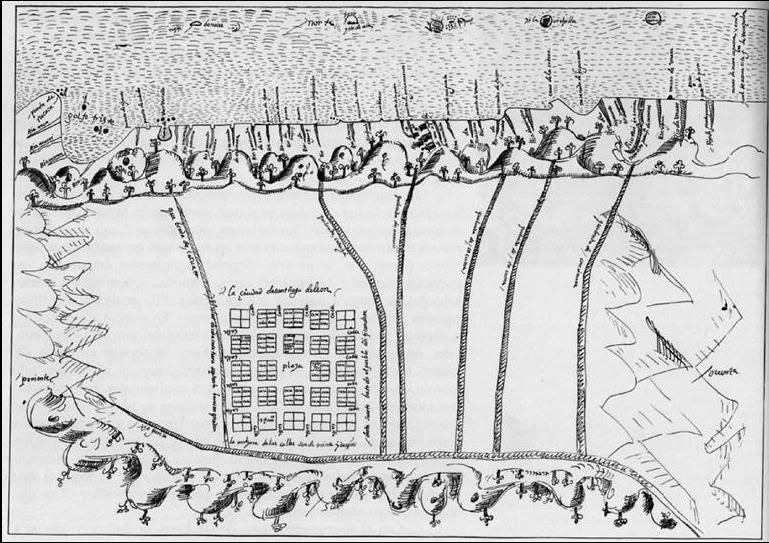
First plan of the city of Caracas by Juan de Pimentel, 1578. Part of the *Carta al Rey. Relación geográfica y descripción de la Provincia de Caracas y Gobernación de Venezuela” realizado por Juan de Pimentel. Este mapa representa el actual casco histórico de la ciudad.* Source: Academia National de la Historia, Hemeroteca, sección mapas y planos.
The region known today as Venezuela was the product of these European impositions which sought to unify the region into administrative, military, and religious boundaries.
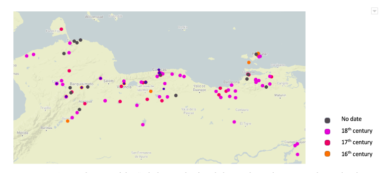
Map showing the Catholic temples founded in Venezuela between the sixteenth and eighteenth centuries. Each color represents a different century.
Even though Catholic institutions in the Province of Venezuela started with a limited presence, by the seventeenth century their efforts increased in solidifying the extension of the Dioceses across the region, accomplishing the reducción of the indigenous population through missions and encomiendas, convent, hospitals, chapels and towns,.[2] Likewise, Africans and people of African descent were forced to convert to Catholicism with the intention of “impose the religious values of Europe and destroy their pagan beliefs and superstitions.”[3] Masters and local authorities were legally obligated to supervise the indoctrination of the slaves into Catholicism and their sacraments, and allow their presence and participation in religious rituals. Blacks, zambos, mulattoes, and free blacks started building “ranchos and conucos in nearby areas to the production of cocoa and where the mayordomos used to gather to attend the religious acts that, permanently or sporadically, were presided by the Catholic priests.”[4]
All this activity increased the establishments of town across the region, most of them expanding and surviving until today. You can learn more about the establishment of the Catholic institutions in Venezuela here
Mapping and registering this process can help us understand better how colonization worked on the ground and the strategic role of the Catholic church in the imperial expansion. It also reflects how civic and religious communities engaged in the quest to create settlements and a new landscape that came hand-in-hand with the attempts to impose, physically and spiritually, Catholic practices.
The main feature of this project is the interactive map, which you can use as an entry point to the [Sacred Spaces directory] (link). The entries on the map contain information about different temples and locations established in the region since the arrival of Europeans in the sixteenth century and prior to the process of independence in the early-eighteenth century.
Using different primary and secondary sources, I am tracing, in space and time, all the religious temples, missions, encomiendas, towns, cities, and villages built between the late-sixteenth and the early-eighteenth centuries. Each of the markers in the map provides background information to the place and access to pages with detailed information from each of the temples displayed on the map. You can also access these pages on the “Sacred Spaces” tab at the top of the page.
I started this visualization project by transforming Graziano Gasparini’s work on Venezuela’s colonial architecture into a visualization tools. From there, it has been growing to incorporate more data about the sacred spaces of the region using a wider array set of sources.
Access the resources page for bibliographical information about Venezuela’s religious history, and the documentary section to read some of the primary sources related to these topics.
This project is still growing, and I am hoping to provide further data about each of these locations students, researchers, and the general public can use to learn more about the built environment and the history of northern South America!
Suggestions or comments? Please contact me!
Footnotes
[1]Dan Stanislawski, “Early Spanish Town Planning in the New World,” Geographical Review 37, 1 (1947): 94-95, accessed October 10, 2014, http://www.jstor.org/stable/211364.
[2]Manuel Pérez Vila, “Estudio Preliminar,” Actas del Cabildo Eclesiástico de Caracas, Compendio Cronológico(Caracas, Academia Nacional de la Historia, 1963) http://archive.org/details/actasdelcabildoe01cate; Manuel Donis Ríos, “La Iglesia como factor unificador del territorio venezolano,” Recursos Ucabistas, 1996, http://w2.ucab.edu.ve/tl_files/sala_de_prensa/recursos/ucabista/jun96/hist.html; Graziano Gasparini, Templos Coloniales de Venezuela (Caracas: Ediciones “A,” 1959).
[3]José Marcial Ramos Guédez, Contribución a la historia de las culturas negras en Venezuela colonial (Caracas: Instituto Municipal de la Alcadía de Caracas, 2001), 57.
[4] Ramos Guédez, Contribución, 30.